Memories of s/v Icarus

Corsair2.sm

A French version of the SAIL Magazine article I wrote as a 17-year-old resurfaced this week. It was published nearly a half century ago about a voyage I made from Florida to New England in a small wooden boat named Icarus.  Courtesy: Thibaud Deves

I am not one who has ever been comfortable waiting around for things to happen.

Today I am in Langkawi, Malaysia waiting for parts to repair the navigational electronics aboard Flying Fish before I set sail across the Indian Ocean.

Forty-seven years ago, I was also waiting. I was counting off the days until high school ended so I could set sail along the eastern seaboard of the United States in an 18-foot plywood sailboat I owned named Icarus.

My brother Bob joined me aboard Flying Fish on the first leg of this circumnavigation. He was also aboard Icarus for the first leg of that voyage. In 1973, Bob was already in college following a sensible path in life studying marine biology, working on a Chinese vegetable farm, and cultivating a crop of high-potency marijuana. He took time off from his busy schedule and we had a delightful passage together. Some days we sailed offshore, on other days we cruised through the Intracoastal Waterway. At Little River, South Carolina Bob went back to Tallahassee for graduate school (and harvest season) while I took a job as a fish gutter on an assembly line with spirited Low-Country black women who sang while they worked and taught me a few words of Gullah. I was broke and happy, and had all of the pan-fried croaker I would ever want to eat.

It was a notable summer. Secretariat had just become the first Triple Crown winner in 25 years. Former White House counsel John Dean began his testimony before the Senate Watergate Committee. The U.S. bombing of Cambodia ended after 12 years of combat activity in Southeast Asia. But then, like now, I felt insulated from world events. Aboard Icarus, I was lost in the fog–both figuratively and literally.

By mid-summer I was alone on Icarus, transiting Delaware Bay from the Chesapeake to New Jersey. I had no navigational gear onboard and I encountered a fog bank. I am a South Florida boy, born and raised. I had never experienced fog. It was a novelty. I could see the air move when I blew it out of my mouth. But couldn’t see anything else. I could certainly hear things, though. The booming fog horns of ships passing me unseen at close quarters echoed out of the gray nothingness. My intention was to sail toward Cape May, New Jersey while estimating my location by dead-reckoning speed, direction, and time. My charts showed buoys with horns and bells, but nothing made sense to me. I remember the day becoming late. I should have made landfall by mid-afternoon. It was transitioning into night. I’ll turn due north, I thought, and that way I can’t miss the New Jersey shoreline of Delaware Bay. I sailed on through the night. There was no shoreline. Just before daybreak the fog lifted and I finally saw some lights. Land ho? Unfortunately, no.

The lights were from commercial fishing boats trawling the Continental Shelf well offshore of New Jersey. It was calm. I thought I was still in the bay. Instead, I was 35 miles out at sea. I pulled alongside a large trawler and shouted out to a mate on deck, “Where am I?” Soon there was a cluster of crewmen and they tossed me a line and lowered a ladder. Icarus tugged at the end the line like a toy poodle on a leash. “You look like you need food and a bunk,” one of the crew said to me. I was escorted to the captain’s mess for breakfast. The captain walked in, wiped sleep from his eyes, raised a fork to his mouth, then set it it down and looked at me. “Who the hell are you?” he roared. I’m from Icarus, I replied meekly. My boat is tied on rope behind your trawler.

The captain could have called the U.S. Coast Guard and ended the voyage of Icarus at that moment. Instead, after some intense interrogation, he said he would tow Icarus within sight of land and then release the tow line once he was sure I wasn’t going to get lost again. This memory is from so long ago now… but I think I remember seeing the captain’s face soften a little. Maybe it was my youthful naïveté, or maybe he saw something in my face that reminded him of himself. He let loose the tow when I was in sight of the amusement park of Atlantic City. Once again I was alone under sail.

How exciting it was to sail Icarus past the Statue of Liberty, along the shoreline of New York City, under the Brooklyn Bridge, through the Hell Gate passage, and into Long Island Sound. I was full of confidence (somehow forgetting about being lost at sea just days earlier). I was Master and Commander of my little ship–and then I ran Icarus onto a rock in the Stamford, Connecticut harbor and put a hole the size of a basketball through her hull.

I was was sinking. I careened Icarus onto a beach and remembered that a year or two earlier I had crewed on a sailboat race from Florida to Jamaica with Mr. Morgan Ames, Commodore of the Stamford Yacht Club. Help from his club was immediately on hand to haul Icarus out of the water. With his instruction (and checkbook) a crew, including his son, immediately began the necessary repairs. That evening Commodore Ames welcomed me into his magnificent Stamford home. “You’ll stay here,” he said, “and we’ll get you some clothing.” At dinner he introduced me to his family. Then a girl entered the room and he said, “And this is my daughter Bambi.” I nearly swallowed my tongue. I was 17 years old, had been alone on the ocean for weeks, and she was very pretty. I was paralyzed. My mouth finally moved. “B-B-Bambi?” I stammered, “Like the baby deer?”

We were the same age. Bambi showed me around Stamford, introducing me to her friends. My selective memory 47 years later remembers her flaxen hair blowing in the summer breeze. I was enchanted. I had dreams of joining the yacht club, of wearing freshly pressed shirts and a navy blue blazer, maybe even attending a debutante ball! In reality, I was just a wild Florida boy who had suddenly turned up on the Ames family doorstep, dirty, broke, and aboard a homemade boat with a hole in it. Mrs. Ames was having none of it. After a few days she took me aside and I remember her words to me as if they were spoken yesterday. With perfect New England elocution she said, “You should know, Jeffrey, that Bambi already has a beau.”

In quick order, Icarus was repaired and I was sailing again. I will always be grateful to the Ames family for their kindness and generosity, and for the life lessons they imparted upon my young wandering soul. Clearly, I had flown too close to the sun.

At the end of that magical summer I found myself in the storied harbor of Newport, Rhode Island. I put a cardboard sign on Icarus that read: “Send A Kid To College, Buy This Boat.” Somebody did, and all too quickly. Within weeks I was enrolled at the University of Florida. I tried to focus on a formal education but I realized that I was waiting again. Waiting for the next opportunity to set sail.

sailor boy small

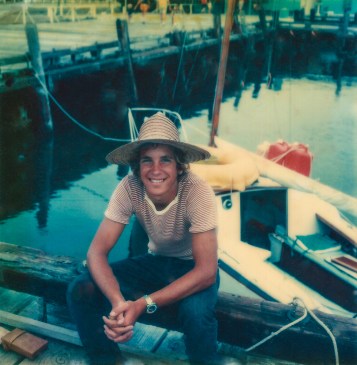
As a boy sailor I was given a long lead to chase my dreams. Here I pose with with 18-foot Icarus during a teenage sailing adventure from Ft. Lauderdale, FL to Newport, RI

NOTE: On passages when I have no cell or WiFi signal, I activate a satellite tracking link that shows my daily position, current weather, and includes a few personal thoughts from the daily log of Flying Fish. I will not be able to respond to messages via satellite but I love the idea that you are sailing along with me. If you would like to follow the daily progress of Flying Fish into Southeast Asia and the Indian Ocean via satellite you can click this link: https://forecast.predictwind.com/tracking/display/Flyingfish

Please subscribe at the bottom of this page so that you don’t miss a new update, and consider sharing this post with others who might enjoy following the voyage of Flying Fish.

To see where Flying Fish has sailed since leaving Key West in 2017, click here: https://cruisersat.net/track/Flying%20Fish

Instagram: FlyingFishSail

Text and Photography © Jeffrey Cardenas 2020

Dodgeball in the Strait of Malacca

JC Strait Malacca

Whacked out from the lack of sleep and constant maneuvering in heavy shipping traffic–with 500 miles to go. Photograph © Jeffrey Cardenas

It’s not just any dodgeball. The ships I am dodging in the Strait of Malacca are displacing up to 500 million pounds. A collision with one of those is gonna leave a mark. Underway on a rainy night in poor visibility, it is all I can think about. That, and the dozens of unlit fishing boats in front of me laying nets and longlines from the edge of the shipping channel to the shoreline.

I had always known that getting adequate sleep underway aboard Flying Fish was going to be the greatest challenge of sailing alone. A neurosurgeon who moonlights as my health counselor suggested that lack of rest might become more dangerous than any other risk I would encounter on this voyage around the earth. Until this week, lack of sleep had not been an issue. Then I entered the Strait of Malacca.

The Strait is a narrow, 550-mile stretch of water between the Malay Peninsula and the Indonesian island of Sumatra. As the main shipping channel between the Indian Ocean and the Pacific Ocean, it is one of the most important–and busiest–shipping lanes in the world. It is only about 1.7 miles wide at its narrowest point near Singapore but nearly 100,000 vessels pass through it each year. This shipping traffic accounts for one-quarter of the world’s traded goods, including some 16 million barrels of oil each day.  In addition, in 2018, there were eight reported piracy and armed robbery incidents in the Strait of Malacca and near Singapore, according to ReCAAP Information Sharing Centre, an agency that tracks attacks against ships in Asia. In 2019, China raised the alert status to its highest level of security for their flagged vessels transiting this choke point. 

So what was Flying Fish doing among this volatile mix? Answer: Trying to get from Point A to Point B without coming into contact with rocks, drift nets, long lines, high-speed ferries, or tankers displacing a half-billion pounds of crude oil.

Flying Fish covers an average of 130 miles per 24-hour day. The 550-mile leg from Singapore to Langkawi is about four days of sailing. No big deal on a journey that has already taken me halfway around the globe, right? Wrong.

On the open ocean, I can sleep. I go over a formal checklist before I close my eyes: I review my charts for shallow water. I do a thorough 360-degree horizon scan. I look at my radar and check for AIS returns. I check current satelite weather charts, I set a course and confirm the autopilot is holding accurately. Then I arm multiple alarms–depth, wind, shipping, proximity, and time. I set two alarm clocks with different tones and I wear a watch on my wrist that shrieks and vibrates like a creature in extremis. Then I can sleep for an hour or two and sometimes longer in the open ocean with good weather. This is how singlehanded sailors rest offshore.

Inshore there is always high anxiety when I close my eyes. I still use the formal checklist but the alarms are set for 15 or 20 minutes. In the Strait of Malacca I would sometimes find traffic converging in less time than that. In the 15,000 miles until now I had never encountered such busy water. Anchoring outside of the Strait was not always an option so I decided to stay awake at night and take quick catnaps during the day. That didn’t work, either. I became deliriously exhausted.

From the log of Flying Fish 14 January 2020:

“All is well at 03:00. There is traffic in the Strait, commercial vessels and fishing boats, but the spacing is good. An overcast sky hides the moonlight. There is light rain and a fresh breeze. Flying Fish is sailing well to windward. I am tired. There is no place within 20 miles to anchor. It is only three hours before first light, daybreak always energizes is me.

In the next moment it is 03:08! I stare at my watch in disbelief. What just happened? Proximity alarms are blaring. Control lights at the helm are flashing. I immediately look to the bow and see a bright green starboard running light directly in front of the mast. What is happening?

As I jump up from the cockpit seat my head, and then my mouth, collides with force against the hard fiberglass surface of the spray dodger. I hear my front tooth crack and taste shattered enamel.

I disengage the autopilot and swing the boat hard to port. The rain on the windscreen of the dodger distorts everything. I brace for impact.

Within seconds I realize that I am looking at MY starboard running light. There is NO collision imminent. The shipping traffic priority alarm is just notifying me that a fishing boat has entered my radar’s Guard Zone perimeter a mile ahead. Everything is working just as it should—except for the captain.

I lost 8 minutes somewhere. I fell asleep sitting up. I was disoriented and nonfunctional when the alarms went off. It is unquestionably the worst mistake a helmsman can make. I fell asleep at the wheel. In a busy sea lane. With poor visibility … The blessing is that I did not hurt anyone.”

When I am finally at anchor in the lee of a small Malaysian island I put myself through a mental review to understand how to prevent this scenario from ever happening again. I realize that publishing this log opens me up to a rush to judgement regarding this mistake. A ship’s log is something different to each captain but I believe it should be a personal testament. Writing it helps me to organize my thoughts. In this situation, it is also a catharsis.

I understand I must better manage fatigue at the helm when I am sailing alone. I have also decided I am not going to fix my tooth. Every time I look in the mirror and see the chip out of my front tooth it will be a visual reminder to me of how a simple mistake can have serious consequences in a place like the Strait of Malacca.

AIS

The AIS (automatic Identification System) returns shows shipping traffic in only a few miles of the Strait of Malacca near Singapore. Flying Fish is in the crosshairs at the lower left.

NOTE: On passages when I have no cell or WiFi signal, I activate a satellite tracking link that shows my daily position, current weather, and includes a few personal thoughts from the daily log of Flying Fish. I will not be able to respond to messages via satellite but I love the idea that you are sailing along with me. If you would like to follow the daily progress of Flying Fish into Southeast Asia and the Indian Ocean via satellite you can click this link: https://forecast.predictwind.com/tracking/display/Flyingfish

Please subscribe at the bottom of this page so that you don’t miss a new update, and consider sharing this post with others who might enjoy following the voyage of Flying Fish.

To see where Flying Fish has sailed in the past year click here: https://cruisersat.net/track/Flying%20Fish

Instagram: FlyingFishSail

Text and Photography © Jeffrey Cardenas 2020


Singapore to Suez (maybe)

Singapore Skyline.sm

The architectural brilliance of Singapore rises from the South China Sea. Photograph © Jeffrey Cardenas

Just as I was finalizing the complicated routing of Flying Fish from Singapore to the Suez Canal, a war of words punctuated by rockets and drones once again inflame the Middle East. The shipping lane where the Gulf of Aden meets the Red Sea passes a mere .88 nautical miles from the shoreline of Yemen. Suddenly, I really miss Polynesia.

I have returned to Flying Fish after a six-week sabbatical in Key West where I was wrapped in the love of family, friends, church, and community. I even managed a rendezvous with my wife in Paris on the flight home. I also found time to visit the family I love in Havana. I share this personal information because it adds relevance and a point of reference to my decision to continue sailing–often alone–around the world. This short sabbatical at home reminds me that I need to make my decisions very carefully now. 

Flying Fish has logged some 15,000 miles–halfway around the world–since leaving Key West two years ago. There have been visits to paradise along the way (Huahine!) and a few moments of drama (nearly losing a toe to an errant hatch board) but no leg of the journey so far has presented the challenges that lie ahead.

I set sail tomorrow into the Straits of Malacca, a narrow, 550-mile stretch of water between Singapore, the Malay Peninsula, and the Indonesian island of Sumatra. This is the main shipping channel between the Indian Ocean and the Pacific Ocean. Nearly 100,000 vessels pass through the Strait each year, carrying one-quarter of the world’s traded goods. Flying Fish will be one small blip on a very busy radar screen.

Ahead lies Malaysia with its historic megalopolis of Kuala Lumpur and the scenic wonderland of Langkawi. At the northern end of the Straits, Thailand beckons with the crystalline water and sugar sand beaches of Phuket. Then it is time to turn Flying Fish westerly and follow the path of Venus into the Indian Ocean.

The journey going forward will take me past Sri Lanka, India, and to the Maldive Islands some 1,500 miles away in the center of the Indian Ocean. The Maldives are made up of a thousand individual islands and some, like those on the Baa Atoll, have bioluminescent beaches that glow at night.

I plan to linger in that glow of bioluminescence because it will be at this point that I will have to choose to sail Flying Fish to either the north or the south of the continent of Africa. Either way I go, this will be a sailing passage that will require my undivided attention.

Cape Agulhas at latitude 34.8311° S is the geographic southern tip of Africa and the dividing line between the Atlantic and Indian Oceans. It is one of the roughest bodies of water on earth. North through the Suez Canal is the more logical route except for its history of piracy and the fact that the United States and Iran are threatening mutual mass destruction. Conflict in the Middle East goes back 1,400 years to the death of Mohammad in 632 A.D. The Red Sea Passage transits the heart of one of the most contentious places on earth. 

I never anticipated that this sailing voyage around the world was going to be all coconut palms and hula dancers. I have always accepted the risk because the rewards are so great. I can imagine no fate worse than ending my life on earth fat and bored and sitting in a chair in front of a TV with a gin and tonic in my hand…

I know a surgeon who volunteers vast amounts of his time, talent, and treasure working with Doctors Without Borders repairing gunshot wounds in war zones around the world. He sent me a note this week, signing off with the well-known quote from Friedrich Nietzsche:

“The secret of realizing the greatest fruitfulness and the greatest enjoyment of existence is: to live dangerously! Build your cities on the slopes of Vesuvius! Send your ships out into uncharted seas!”

And so I go.statue.sm

NOTE: On passages when I have no cell or WiFi signal, I activate a satellite tracking link that shows my daily position, current weather, and includes a few personal thoughts from the daily log of Flying Fish. I will not be able to respond to messages via satellite but I love the idea that you are sailing along with me. If you would like to follow the daily progress of Flying Fish into Southeast Asia and the Indian Ocean via satellite you can click this link: https://forecast.predictwind.com/tracking/display/Flyingfish

Please subscribe at the bottom of this page so that you don’t miss a new update, and consider sharing this post with others who might enjoy following the voyage of Flying Fish.

To see where Flying Fish has sailed in the past year click here: https://cruisersat.net/track/Flying%20Fish

Instagram: FlyingFishSail

Text and Photography © Jeffrey Cardenas 2020


Indonesia Farewell

326DE474-6B09-4A9A-A797-9DD3CA24E463

Dayak children in the river village of Sungai Sekonyer want to save the world. The village is comparatively prosperous with half of the adults working as river guides and rangers in the national park, and the other half working for the palm oil industry.  Photograph © Jeffrey Cardenas

Indonesia, its people and their environment, are on the threshold of a major sea change. The capital of Jakarta, already overcrowded and toxically polluted, is now sinking into the ocean.

The proposed solution: Move the capital to the jungle of Borneo and start from scratch–the equivalent of moving Washington D.C. to the Florida Everglades (no wisecracks please about Washington already being a swamp.) This move to Borneo would install Indonesia’s government seat of power in a place where nature already rules.

Jakarta’s proposed move to Borneo is a metaphor, of sorts, for issues bedeviling many developing countries I have visited on my circumnavigation in Flying Fish. It is a familiar story of unchecked commercialism fueled by the overwhelming pressure of tourism complicated by too many mouths to feed resulting in the degradation of the natural resource and the quality of life of its inhabitants.

Jakarta is currently sinking at a rate 6.7 inches per year, and in 30 years it is estimated that 95 percent of North Jakarta will be submerged, according to a report in Singapore’s Business Insider. The rapid urbanization of 30 million people in Jakarta’s greater metropolitan area as well as the uncontrolled extraction of ground water for mega malls and luxury hotels is draining the Java aquifer. The result is that the ground under Jakarta caving in.

Critics say that dropping the government seat of Indonesia and 1.5 million new residents into a natural habitat like East Kalimantan, Borneo is a recipe for environmental disaster. The location of the proposed new city is surrounded by Kutai National Park, known as a sanctuary for some of the last wild orangutans in existence. Deforestation has already been a problem in Borneo for decades. Its rainforests have been slashed and burned to make way for gold mining and palm oil plantations. Between 1973 and 2015, Borneo lost some 16,000 square miles of its old-growth forests due to land clearing and burning. That deforestation has released a steady torrent of carbon emissions, along with other forms of pollution such as carbon monoxide, cyanide, and ammonia. In 2010, land clearing for palm oil plantations in Kalimantan alone released more than 140 million metric tons of carbon dioxide – about the same as the annual emissions of 28 million cars, according to the research journal Nature.

7402B94D-4CC5-4F87-A999-C63758BFF247

A wild orangutan mother nurses her baby with equal attention focused on potential threats from human visitors. Photograph © Jeffrey Cardenas

Everywhere Flying Fish has visited in Indonesia there have been similar conflicts of man and nature competing to survive.

In Bali, the long-tailed macaque monkeys are so integrated into human society that in places like the Uluwatu Temple they harass visitors for food (and sunglasses, jewelry, wallets) and then masturbate in front of tourists if they don’t get what they want.

From Lombok, Flying Fish sailed to the Gili Islands where the water demand for tourist resorts is so acute that small vessels work at all hours transporting tanks of fresh water from the mainland to the resorts.

At the remote island of Bawean in the Java Sea there is a stunning variety of coral species. Sadly, some of the most exquisite coral has been trampled underfoot by subsistence fishermen who walk over it at low tide.

Nature is not at fault here. We are. We are loving the world to death.

Other examples in Southeast Asia of extreme human pressure on the environment: Maya Bay in Thailand had the misfortune to be chosen for the set of Leonardo DiCaprio’s The Beach. Before the movie, Maya Bay received about 100 visitors a day. After the movie that number climbed to 5,000 people per day. Over a million tourists swarmed the beach in 2017 and an estimated 80% of the coral in the region was destroyed due to the impact of overtourism.  In June of 2018, Thailand’s Department of National Parks, Wildlife, and Plant Conservation announced that the natural habitat might be irreparably damaged. Four months later, the Thai government shut down the beach indefinitely.

In 2012, the magazine Travel+Leisure declared Boracay in the Philippines as “The Best Island in the World.” Boracay is less than four square miles but by last year 6.6 million people annually were inundating the island. Sewage was running from hotels directly into the ocean. Inspectors found over 800 environmental violations. Figures showed that the rubbish generated per person on Boracay was more than three times higher than in the capital of Manila. The Philippine government shut down the entire island to reconstruct the infrastructure and give the natural habit time to rest.

In July, the Indonesian government announced that it would close one of its most iconic destinations, Komodo Island, amid concerns that increasing numbers of tourists were affecting the animals’ mating habits. Food handouts were making them docile. In addition, there were also people stealing dragons and selling them on the black market. Last year, nine men were arrested on suspicion of selling more than 40 Komodo dragons for about $35,000 each. Then, in an abrupt about-face, the Indonesian environment ministry cancelled plans to close Komodo Island to tourists and instead proposed targeting visitors with a $500 USD entry fee. Viktor Bungtilu Laiskodat, governor of East Nusa Tenggara, told the UK Guardian, “Only people with deep pockets will be allowed to [see Komodo dragons]. Those who don’t have the money shouldn’t visit the park since it specifically caters to extraordinary people.”

Nearly 200,000 tourists visit Komodo each year, many with a bucket list ambition to pose in a selfie with “one of the world’s most deadly reptiles.” Aboard Flying Fish I had intended to do the same thing until I realized how humiliating it would be to both the lizards and me.  Flying Fish sailed past Komodo Island and I wished the dragons good luck.

Humanity.sm

Graffiti marks a hewn tree stump on the beach at Gili Air. Photograph © Jeffrey Cardenas

I did not begin this voyage with preconceived ideas of how, or exactly where, I would travel. The joy of travel, for me, is in its fluidity. As I prepare to leave Indonesia I do so with a heavy heart. I have fallen in love with this country, and with its people.

I think about Commandant Lahan Bacho of the Indonesian Coast Guard who welcomed me onto his ship and into his home in the Kai Islands. Despite knowing I was Catholic, he invited me join him at his mosque where we prayed together.

Indonesian Commandant Lahan Bacho, at the helm of Flying Fish. Photograph © Jeffrey Cardenas

Jamil Udin is a Renaissance man in the tiny Lombok village of Ekas. He is an entrepreneur in his 20s who runs a single-counter general store, a homestay for surfers, he’s a mobile phone provider, a tour guide, and a fixer. He’s also the village nurse, and he delivers babies.

On Gili Gede I met Alain Nedelec, a French expat and his Indonesian wife Ita, owners of the eclectic Tanjungan Buket restaurant with a kitchen serving exquisite French/Indonesian cuisine.

A happy mob of Indonesian kids entered my life (and my heart) one Saturday on the beach at Selong Belanak as they joined 20 million volunteers worldwide picking up garbage on World Cleanup Day.

One night in Bali I fell under the spell of the gorgeous Yeye Luh Swastini, a living Hindu deity, who presented me with a bronze statue of the Indonesian Goddess of the Sea, Nyai Roro Kidul. The goddess is often described as a mermaid, a mythical creature said to be able to take the soul of anyone who she wishes, and she usually prefers handsome young men. That rules me out.

Forever memorable was 20-year-old Diaz Nugraha, aka the Reptile Boy of Borneo. For three days he showed Lilly and me the wildlife of Tanjung Puting National Park, including a baby spitting cobra, brightly speckled water monitor lizards, tarantulas, scorpions, hornbills, a spectacular False gharial crocodile. He also introduced us to the magnificent orangutans of Borneo.

Croc.sm

A False gharial crocodile warming in the sun near the headwaters of the Sekonyer River in Kalimantan, Borneo. Photograph © Jeffrey Cardenas

In my farewell to Indonesia I cannot help but wonder what the future holds for these people, and the places that they call home.

###

I want to extend love and gratitude to my daughter Lilly who joined me for six weeks aboard Flying Fish as we sailed through Indonesia.

LC Diaz River.sm

Lilly and Reptile Boy Diaz Nugraha riding the riverboat deep into the jungle of Borneo. Photograph © Jeffrey Cardenas

I will be taking a short sabbatical from Flying Fish to visit my home in Key West for the holidays. I will return to the boat in Singapore in mid-January to continue my passage west toward Africa and eventually back to Florida. I hope you will continue to follow to voyage of Flying Fish.

NOTE: On passages when I have no cell or WiFi signal, I activate a satellite tracking link that shows the daily position, current weather, and includes a few personal thoughts from the daily log of Flying Fish. I will not be able to respond to messages via satellite but I love the idea that you are sailing along with me. If you would like to follow the daily progress of Flying Fish into Southeast Asia and the Indian Ocean via satellite you can click this link: https://forecast.predictwind.com/tracking/display/Flyingfish

Please subscribe at the bottom of this page so that you don’t miss a new update, and consider sharing this post with others who might enjoy following the voyage of Flying Fish.

To see where Flying Fish has sailed in the past year click here: https://cruisersat.net/track/Flying%20Fish

Instagram: FlyingFishSail

Text and Photography © Jeffrey Cardenas 2019


Into The Northern Hemisphere

DCIM136GOPROG0065428.JPG

Flying Fish, becalmed, at Longitude 105 03’.603 E and Latitude 00 00’.000 N. Photograph © Jeffrey Cardenas

It is now autumn in the South China Sea. An hour ago it was spring. There was no winter. It is always summer on the equator. We have sailed from the Southern Hemisphere into the Northern Hemisphere. The ship’s log shows 14,971 nautical miles.

It is fitting that my daughter Lilly has joined me on this passage. Exactly 620 days ago, Lilly and I sailed together from the Northern Hemisphere into the Southern Hemisphere, at a point southeast of the Galapagos, on a westbound passage to Tahiti and beyond.

The equator is 24,901 miles long. On land it crosses the Batu Islands of Sumatra, the Maldives in the Indian Ocean, Somalia, Kenya, Uganda, and the Democratic Republic of Congo. The equator passes through the mouth of the Amazon River, the pre-Colombian ruin of Catequilla, the island of Isabela in the Galapagos. It continues westward through Oceania near the atolls of Aranuka, Nonouti, and Kirbuti. The equator meets Indonesia at the Gebe Islands and continues through the Halmahera Sea, the Molucca Sea, and the Java Sea. It crosses Borneo at Pontianak. Finally, at Longitude 105 03’.603 E and Latitude 00 00’.000 N, it is where we meet the equator today.

Sailors have always noted crossing the equator. In the 19th century (and later) line-crossing ceremonies were sometimes brutal events. Pollywogs, as first-timers were called, were beaten with boards and wet ropes, and often thrown over the side of the boat and dragged from the stern. Charles Darwin notes in his diary that on his first crossing of the equator he was “placed on a plank” and tilted into the water after having his face and mouth “lathered with pitch and paint.”

Lilly and I have celebrated our two crossings more moderately. A small ration of rum followed a voluntary swim as we crossed over the invisible line. Our event is recorded with a portrait of a young sailor at peace in the sea.

Surface of Water

The equator, from above the surface of the water in the South China Sea. Photograph © Jeffrey Cardenas

I hope you continue to follow to voyage of Flying Fish

For upcoming passages when I have no cell or WiFi signal, I have activated a satellite tracking link that shows the daily position, current weather, and includes a few personal thoughts from the daily log of Flying Fish. I will not be able to respond to messages via satellite but I love the idea that you are sailing along with me. If you would like to follow the daily progress of Flying Fish into Southeast Asia and the Indian Ocean via satellite you can click this link: https://forecast.predictwind.com/tracking/display/Flyingfish

Please subscribe at the bottom of this page so that you don’t miss a new update, and consider sharing this post with others who might enjoy following the voyage of Flying Fish.

To see where Flying Fish has sailed in the past year click here: https://cruisersat.net/track/Flying%20Fish

Instagram: FlyingFishSail

Text and Photography © Jeffrey Cardenas 2019