The Eternal Life of Medusa

OLYMPUS DIGITAL CAMERA

Some species of jellyfish have evolved to allow perpetual regeneration–the secret of eternal life. © Jeffrey Cardenas

This exotic Indonesian bell jellyfish first made its presence known to me this morning as a splash of fire against the side of my neck. The microscopic nematocysts—spring-loaded darts of toxin—got my attention as I snorkeled over a coral wall near Pulau Gililayar. The pain was not as intense as that of a Portuguese man-o-war, and nothing like the box jellyfish that can and has been fatal to some swimmers.

Once the sting subsided I took a few moments to observe my antagonist, and then later read up on it.

According to Dr. Lisa-Ann Gershwin, a jellyfish researcher based in Tasmania, when some species of medusa die they sink to the ocean floor and, amazingly, their cells then regenerate into polyps. From these polyps a new jellyfish will emerge. This means that when certain jellyfish become weakened either by age or illness they can call up this incredible survival mechanism and transform into an entirely new being.

Jellyfish have evolved to learn the secret of eternal life.

“This was a real mind blower for all of us,” said Dr. Gershwin in a recent BBC interview. “It’s one of the most amazing discoveries of our time.”

I’ll take a little shot of pain anytime to learn about something as fascinating as the life, death, and rebirth of jellyfish.

###

For upcoming passages when I have no cell or WiFi signal, I have activated a satellite tracking link that shows the daily position, current weather, and includes a few personal thoughts from the daily log of Flying Fish. I will not be able to respond to messages via satellite but I love the idea that you are sailing along with me. If you would like to follow the daily progress of Flying Fish into Southeast Asia and the Indian Ocean via satellite you can click this link: https://forecast.predictwind.com/tracking/display/Flyingfish

Please subscribe at the bottom of this page so that you don’t miss a new update, and consider sharing this post with others who might enjoy following the voyage of Flying Fish.

To see where Flying Fish has sailed in the past year click here: https://cruisersat.net/track/Flying%20Fish

Instagram: FlyingFishSail

Text and Photography © Jeffrey Cardenas 2019

The Colors of Tual, Indonesia

Tual City.med

On the Tual side of the archipelago of Kei Islands these homes–and a mosque–were painted to honor a visit by Indonesian President Joko Widodo. Photograph © Jeffrey Cardenas

In the Kei Islands of Dullah and Kecil a narrow wooden bridge seperates the cities of Tual and Langgur. One side is Muslim, the other side is Christian. Together they are one Indonesia.

Centuries ago, the islands were located on a key maritime route of the spice trade which extended from the Moluccas southwards towards the Lesser Sunda Islands and Java. By 1610, the Dutch East India Company had become the dominant power and Indonesian elders were replaced by Europeans.

During the Second World War, Japanese soldiers landed in the islands. The Dutch were unable–some say unwilling–to defend Indonesia, and two days after Hirohito surrendered in 1945, Indonesia began a bloody war of Independence with the Netherlands to gain their sovereignty.

Tomorrow marks Indonesia’s Day of Independence.

Tual Indonesian Girl

A young Muslim girl wearing a hijab meets Flying Fish docking at the Tual Coast Guard wharf. Photograph © Jeffrey Cardenas

###

For upcoming passages when I have no cell or WiFi signal, I have activated a satellite tracking link that shows the daily position, current weather, and includes a few personal thoughts from the daily log of Flying Fish. I will not be able to respond to messages via satellite but I love the idea that you are sailing along with me. If you would like to follow the daily progress of Flying Fish into Southeast Asia and the Indian Ocean via satellite you can click this link: https://forecast.predictwind.com/tracking/display/Flyingfish 

Please subscribe at the bottom of this page so that you don’t miss a new post, and consider sharing this post with others who might enjoy following the voyage of Flying Fish.

To see where Flying Fish has sailed in the past year click here: https://cruisersat.net/track/Flying%20Fish

Text and Photography © Jeffrey Cardenas 2019

Goodbye Oceania, Hello Southeast Asia

Wing and Wing Westward.sm

Flying Fish sailing westward, downwind, wing-on-wing. © Jeffrey Cardenas

I remember with vivid clarity the moment 20 months ago when Panama’s Miraflores Locks opened and Flying Fish was floating for the first time in the Pacific Ocean.

Tomorrow I begin my departure from this beautiful ocean–with so many memories–and sail onward toward the new and strange world of the Indian Ocean.

There is no mechanical demarkation between these two oceans as there was at the Panama Canal. Still, I sense the mingling of these ocean waters. I am leaving the Coral Sea to the east, transiting the Torres Strait, and crossing west into the Arafura and Timor Sea–from Oceania to Asia. I will linger for some time in Malaysia and Indonesia before deciding how, when, or if Flying Fish will make the nearly 5,000-mile passage across the Indian Ocean to South Africa.

It was suggested that better routing might be across the Indian Ocean to the Red Sea and into the eastern Mediterranean via the Suez Canal. If that happens, Flying Fish would be hitching a ride on the deck of a freighter in an armed convoy past Yemen, Somalia, and the Gulf of Aden. I’m no Rambo.

But those are thoughts for another day… Now, the focus is on tomorrow.

There are 18,307 islands in the Indonesian archipelago and I don’t want to touch any of them with the keel of Flying Fish. I am prepared and well-rested. My various body parts have healed completely from previous onboard dramas. The sailboat is tuned and ready for new water. Onward!

FF pano

###

Today’s log entry and position of Flying Fish. 

As I mentioned in the last post I have activated a satellite tracking link that shows the daily position, current weather, and includes a few personal thoughts from my daily log. I will not be able to respond to messages via satellite but I love the idea that you are sailing along with me.  If you would like to follow the daily progress of Flying Fish into Southeast Asia and the Indian Ocean you can click this link: https://forecast.predictwind.com/tracking/display/Flyingfish 

Please subscribe at the bottom of this page so that you don’t miss a new post, and consider sharing this post with others who might enjoy following the voyage of Flying Fish.

To see where Flying Fish has sailed in the past year click here: https://cruisersat.net/track/Flying%20Fish

Text and Photography © Jeffrey Cardenas 2019


Off the Edge of the Earth

Hope Islands

Flying Fish, alone at Hope Island on the Great Barrier Reef. Photograph © Jeffrey Cardenas

Off the edge of the earth, or so it seems…

Flying Fish continues onward into the Torres Strait and then to SE Asia. WiFi and cell signals are rare to non-existent (now being an exception).

If you are following the passage of Flying Fish, I have set up a new satellite link—Passage Post Notes—at https://forecast.predictwind.com/tracking/display/Flyingfish. These notes are only a line or two from the daily log of Flying Fish but they show where I am, the current weather, they give a sense of the passage–and I can post without WiFi or cell.

I will continue to upload full-length posts here at FlyingFishSail.com when / if I have the bandwidth. Unfortunately, I cannot respond to your comments via satellite. Sailing singlehanded, I value communication with readers (it’s so much better than talking to myself). For now, however, the post notes are the best I can do.

Thanks for sailing with me as I navigate through this amazing world.

Nautilus Shell.sm

A nautilus shell washed ashore on the sand flats at Forbes Island National Park on the Great Barrier Reef. Photograph: © Jeffrey Cardenas

###

Please subscribe at the bottom of this page so that you don’t miss a new post, and consider sharing this post with others who might enjoy following the voyage of Flying Fish

To see where Flying Fish has sailed in the past year click here: https://cruisersat.net/track/Flying%20Fish

For current weather along the route click here: https://forecast.predictwind.com/tracking/display/Flyingfish

Text and Photography © Jeffrey Cardenas 2019

Cape Tribulation

“Because here begun all our troubles.”—Capt. James Cook / June 11, 1770

Cape Trib moonset bw hor.sm

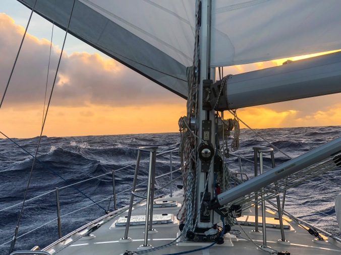
Under a full moon, Flying Fish sails past Australia’s Cape Tribulation where just offshore Cook’s Endeavour nearly foundered on the Great Barrier Reef.  Photograph: © Jeffrey Cardenas

Actually, the trouble for Capt. James Cook had started several days earlier when “some Malicious persons” among the crew of Endeavour, unhappy about being served a continual diet of stingray soup, assaulted Cook’s clerk as he lay drunk in his berth. They cut off his clothing, and if that was not humiliating enough, they went back and “cut off a part of both of his Ears as he lay sleeping in his bed,” according to Cook’s journal. [Flying Fish footnote: And some wonder why I sail singlehanded.]

Things got worse for Cook and the crew of Endeavour. On a moonlit night, as they sailed past Cape Tribulation, Endeavour “struck and struck fast” against what is now known as the Great Barrier Reef.

As I read this account in The Explorations of Captain James Cook in the Pacific, I am in Flying Fish and also sailing past Cape Tribulation under a full moon. The narrative of Cook and the Endeavour raises the hair on the back of my neck as Flying Fish pushes onward along this hazardous coastline.

Cook had been asleep in his cabin when the ship impacted the reef. He raced to the Quarter deck, according to the diary of the ship’s botanist Joseph Banks, and in his underwear Cook began managing the crisis. He ordered sails reduced and lowered the ship’s longboats to carry kedging anchors offshore in an attempt to pull the ship off the reef. The Endeavour did not move.

Next Cook ordered the ship to be made lighter and guns, ballast, food, and water were jettisoned overboard. More than 50 tons of critical supplies were thrown into the sea. Still the ship remained hard aground.

The following day as the tide rose the ship was finally kedged off the reef and pulled into deeper water. Now, however, there was an even greater peril aboard Endeavour. The ship was flooding and four pumps could not keep up with the incoming sea water. “This was an alarming and I may say terrible Circumstance and threatened immediate destruction to us as soon as the Ship was afloat,” Cook wrote.

Then two amazing and fortuitous things occurred. First, a coral head had lodged in a hole in the hull. Had it dropped out, Endeavour would have sunk on the spot. Still, water was coming in faster than the pumps could remove it. A midshipman named Jonathan Monkhouse came up with a brilliant idea: He suggested wrapping a sail around the damaged hull like a diaper, a technique known as fothering. Cook gave the order to coat the sail was in oakum, wool, and “sheeps dung or other filth” to help it adhere to the hull. The temporary repair worked. Endeavour was severely wounded, but not lost.

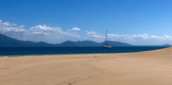
Cook needed a secure place to careen his ship. He looked to the northwest and saw two small islands. He named them Hope. He and his crew looked longingly at Hope Islands but with an unfavorable wind they could not maneuver the damaged ship to safety there.

Cape Tribulation and the continent of Australia loomed only 15 miles to the west but it was a mountainous and unwelcoming shoreline. Endeavour struggled into Weary Bay but it was too shallow to bring the ship ashore. Cook was despondent. He named one local landmark Mount Misery, another Mount Sorrow. Cook wrote that the damaged ship “would not work.” After a week of being “entangled among shoals” a scouting party finally found a river mouth deep enough to accommodate Endeavour’s 12-foot draft. His ship and his crew were safe, but repairs would take nearly two months before they could sail once again.

Two and a half centuries of full moons have passed over Hope Islands where Flying Fish has dropped anchor in a pocket of deep water surrounded by an endless labyrinth of coral reef. It is a lonely and beautiful anchorage. A relentless wind blows from the southeast. In the falling darkness under a rising moon I dinghy ashore. At low tide I wade along a trail of rock and rubble that lays exposed for several hundred yards in the direction of Endeavour Reef. I feel the weight of history here, and it gives me strength.

Captain James Cook (1728-1779) *oil on canvas  *127 x 101.6 cm  *1775-1776

Portrait of Capt. James Cook by Nathaniel Dance-Holland / National Maritime Museum, United Kingdom. Image in Public Domain

###

Please subscribe at the bottom of this page so that you don’t miss a new post, and consider sharing this post with others who might enjoy following the voyage of Flying Fish

To see where Flying Fish has sailed in the past year click here: https://cruisersat.net/track/Flying%20Fish

For current weather along the route click here: https://forecast.predictwind.com/tracking/display/Flyingfish

Text and Photography © Jeffrey Cardenas 2019